| PartnerSHIPS: Monitoring Mediterranean surface waters with ships of opportunity. |
Coordinators:
NE Mediterranean: Anastasia Miliou
Archipelagos Institute of Marine Conservation, Samos Isl., Greece
TransMED coordination (SST data): Isabelle Taupier-Letage
Mediterranean Institute of Oceanography (MIO), CNRS Aix-Marseille University, France
Acidification coordination (to be decided)
Data portal : http://www.ifremer.fr/transmed/index.php?EX=data
|
 |
| Rationale |
The ocean-atmosphere coupling largely shapes the climate of the Earth. Global warming combined with human-induced pressures is now a key driver of environmental changes. The original topography of the Mediterranean sea, a semi-enclosed sea, composed of several sub-basins separated by straits and channels at different depth, makes this sea very sensitive to atmospheric forcing and changes. CIESM findings indicate that Mediterranean water masses have steadily become saltier and warmer in recent decades at all depths and anywhere in the Basin (CIESM WK 16, 2002). All waters (even the deepest) have been acidified since the beginning of the industrial era (Touratier and Goyet, 2011). Slight changes can be evidenced at the surface and in depth and long term observations can provide a wide range of environmental and climatic indicators. |
The sea-surface layer is the oceanic boundary region between the ocean and the atmosphere, it plays a vital role in affecting physical and chemical transfers between these two major environmental reservoirs (nutrients, anthropogenic CO2, heat, wind, precipitation, waves, evaporation, etc.). This has important consequences on marine biodiversity, ecosystem functioning and on water circulation. Tracking long-term hydrological and biogeochemical changes across the Basin in surface waters, along coastal and in central zones is required to assess long term variability and to unedrstand the functioning of the Mediterranean Sea. Monitoring of surface waters using buoys, piles and platforms with in situ sensors is very expensive. To overcome this problem, a partnership between scientists, governments and ship companies in different regions of the world allows to take advantage of regular routes taken by ferries and cargoes to keep a "watch" on water features (Figure 1). Automated instrument packages on ships of opportunities are in use since many years, starting form the simple collecting plankton samples during regular ship cruises up to the most recent sophisticated multiparameters box with an ensemble of different sensors and biogeochemical analysers. They allow building time series with a relatively high temporal scale. |
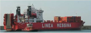
Fig. 1 A cargo from the company Linea Messina, partner of PartnerSHIPS, operating between Genoa, Malta and Libya.
|
| The CIESM PartnerSHIPS programme |
The aim of the CIESM PartnerSHIPS programme is to develop a network of ships of opportunity (Figure 2) for automated monitoring of the surface waters of the Mediterranean, using a complex of different physical, chemical sensors to measure the physical and biogeochemical parameters of the Mediterranean (temperature, salinity, oxygen and pCO2, chlorophyll, etc.).
This sea presents one of the more dense maritime traffic in the world, oil tankers, shipping boats, car ferries take many routes across the Basin. A network of ships of opportunity allows a (quasi)synoptic view at the basin scale, not only along the coast but in central zones and in southern/eastern parts of the Mediterranean where the data are missing. Sub-sampled data are sent in real time (via Inmarsat), and contribute to operational oceanography. |
|
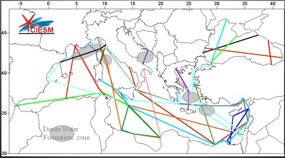
Fig. 2 CIESM PartnerSHIPS potential network.
|
| Pilot phase |
A pilot phase was initially implemented in the western part of the Mediterranean. In March 2005, a SeaKeepers 1000TM Module (prototype thermosalinometer plus meteorological station) and a fluorometer were installed on a ferry operating between Marseille, Algiers and Tunis to study circulation, salinity and surface temperatures where Mediterranean and Atlantic waters meet. The SNCM car-ferry "Méditerranée", crosses the whole western basin, approximately once per week.
This pilot system, running in 2005-2006, demonstrated many problems, such as bio-fouling. |
| Current phase |
A new prototype, simplified, has been designed in collaboration with INSU (Division technique) and the HYMEX programme (MISTRALS, CIO Environment). Successfully tested on Tethys 2 in 2006 (and updated until 2009), it has been installed on a container ship from our partner Linea Messina Company (Figure 1). Since May 2010, the CIESM PartnerSHIPS project operates between Genoa (Italy), Malta and Libyan harbours.
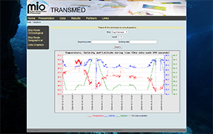
The figures below illustrate the shipping route (Figure 3) and SST data collected along the way in mid-December 2010 (Figure 4). |
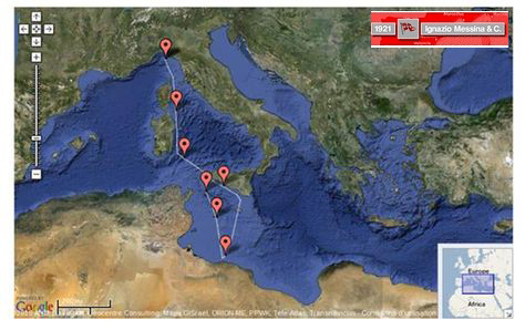 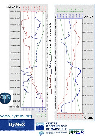
Fig. 3 Shipping route currently monitored and Fig. 4 Sea Surface Temperature and Salinity Data.
|
These data, once synthesized will be integrated into the CIESM GIS metabase. The prototype will be replicated and installed on other ships. The CIESM PartnerSHIPS Program shall be implemented in time in the overall Basin.
|
In the future - For a basin synoptic view |
A network across the Basin
In the Mediterranean sea where the maritime traffic is very dense, measuring physical and bio-geochemical parameters through a system fully autonomous is adequate since cargoes and ferries take regular short routes. The PartnerSHIPS optimal network is represented in Figure 2 and is based on existing/actual shipping routes requiring collaboration and partnership with different maritime transport companies. It includes routes crossing the whole basins, monitoring the dense water formation areas (shaded areas), and investigating poorly known areas (southern/eastern parts).
A multiparametric sensor box
A larger set of parameters could be monitored through the system. Regular data on pH and pCO2 would give some indication on the acidification level of the sea. Measurement of chorophyll a fluorescence and detection of main algal groups, measurements of nutrients (ammonium, nitrate, phosphate, silicate) could provide complementary data to ongoing international programs on eutrophication of the sea or early algal bloom detection.
The PartnerSHIPS sensor box will be further adapted to these different parameters and link with meteorological sensor package (MétéoFrance/HYMEX).
A comprehensive database
A database will be implemented for storing and managing the field data, which will be integrated into physical models, forecasting models providing trends of the Mediterranean hydrodynamics and water circulation.
The CIESM PartnerSHIPS Programme, together with the CIESM Hydrochanges Programme will provide, on long term, data to serve the scientific Mediterranean community. The common access to all time-series will support the effort to get the comprehensive picture of the functioning of the Mediterranean Sea. |
| References |
CIESM WK N°16. Tracking long term hydrological change in the Mediterranean Sea, Monaco, 22-24 April 2002, CIESM Workshop series.
Touratier F. and Goyet C., 2011. Impact of the eastern Mediterranean Transient on the distribution of anthropogenic CO2 and first estimate of acidification for the Mediterranean Sea. Deep Sea Research Part I: Oceanographic Research Papers: 58 (1): 1-15. |
| Cooperating agencies: DT INSU, LOB/CNRS/Université de la Méditerranée, HyMeX program |
|