Yellow ‘submarines’ surveying the Sea Yellow ‘submarines’ surveying the Sea
July 2006, CIESM News
The ocean’s role in future climate is one of the key questions in climate change research. To address this contemporary issue, more data of the marine system, in quasi real time, are needed to better understand the highly complex interplay of processes occurring at various spatio-temporal scales. To consolidate their observational strategy of the whole water column, new, exciting tools are now available to marine scientists: “underwater gliders” that gather data on physical, bio-geochemical and bio-optical water properties and changes. These torpedo-shaped underwater vehicles maneuver autonomously through the ocean, silently diving and climbing across water masses.
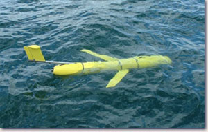
An underwater glider on the sea surface |
Temperature and salinity versus depth, the absorption and scattering of light in the water column are some of the measurements obtained by sensors during a typical mission. The scientific payload, however, has rigorous constraints, starting with size, because the major part of the glider is reserved for glider mechanics, battery storage and communication equipment.
The data collected by the scientific instruments during a dive are transmitted, once the glider is back to the surface, via satellites directly to the researcher’s office. This is not only practical, but also enables to receive continuous, near-to-real time marine environmental information at relatively low cost.
In a recent exchange with Dr Hervé Claustre, an oceanographer based at the ‘ Laboratoire d'Océanographie de Villefranche s/mer ’ (France), we discussed the future perspectives opened by this new technology. |
Hervé Claustre was awarded very recently the CNRS Silver Medal, a highly esteemed distinction for the originality, quality as well as international importance of his scientific work.
Here, he gives his point of view about using underwater gliders for observations in the Mediterranean Sea and gives some insight to his future research projects.
__________________________________________
What are the advantages (disadvantages) by using underwater gliders for your research and in which parameters are you particularly interested?
Gliders are autonomous, they do not need much energy to run and require small boats (zodiacs) only to get them to work. |
| Some technical information of a glider, used as scientific instrument platform: |
length |
~ 1.8 m |
weight |
~ 50 kg |
speed |
30-40 cm/s |
max. diving depth |
1000 m |
max. time range of mission |
months |
operational area |
all oceans |
max. spatial range of mission |
~ 1500 km |
|
In addition, gliders allow to study the functioning of the ocean surface layer on a suitable continuum of scales: on a spatial scale, from the sub-mesoscale (~1 km) to basin scale (e.g., the Ligurian Sea), and on a temporal scale, from hourly to seasonal. In particular, phenomena/processes that appear on small spatial and temporal scales are often unrecognised, because they are difficult to tackle or even unapproachable by traditional observational strategies (i.e., using oceanographic vessels). Thanks to the gliders, intensive measurements of marine properties/processes can be carried out at lower cost. Moreover, for intensive sampling and data acquisition fleets of gliders can be operated if specific scientific or operational questions (e.g., mapping a red tide event) require a simultaneous deployment.
Parameters of interest:
- Temperature and salinity
- fluorescence of chlorophyll a, an index of phytoplankton biomass
- fluorescence of colour dissolved organic matter, an index of dissolved material
- backscattering coefficient, an index of particle load. In open ocean water this coefficient is a proxy of particulate organic carbon while in coastal waters it is also a proxy of mineral material
|
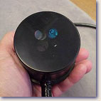 |
A bio-optical miniature sensor implemented on the glider to measure fluorescence of chlorophyll and backscattering. |
|
Down- and upwelling irradiance, allowing to study the water colour and transparency and to derive in situ products essential to validate satellite ocean colour sensors.
W hich technical and organisational challenges are you currently facing in order to investigate marine processes in the upper ocean with underwater gliders?
Technical: Adjusting and improving the original scientific payload by integrating new, innovative biogeochemical and bio-optic sensors.
Organisational: At a laboratory level, the first challenge is to set up the procedures as much as a routine as possible - from launching the glider in the water and controlling its mission to the reception and, in the end, the possible analysis of the data in quasi real time. At another level, a permanent organization challenge is the management of our activity as partner in national and international projects. For example, as part of the recently accepted (EEC FP6) SESAME integrated project, we have established a collaboration between our laboratory in Villefranche and the Center for Marine Sciences in Lebanon for exploring the Lebanese coast at high resolution using glider technology. Thus, establishing new collaborations and coordinating the work with the diverse groups that are involved is a significant part of our activity. It remains however, only a part of our work and, e.g., exchanging scientific ideas is also possible thanks to existing networks and initiatives like the CIESM workshop held last year in Villefranche on mesoscale processes*.
W orking in the Mediterranean Sea area:
What is currently your main field of interest and where does research in near/mid-term future lead to?
The deployment of underwater gliders that will be conducted in the Levantine basin along the Lebanese coast, as part of the SESAME integrated project, will repose on an exploratory objective, because only little is known related to the oceanographic context of the area.
As part of the deployment that we intend to conduct in the North Western Mediterranean Sea we have three main scientific objectives :
- To understand the biological and biogeochemical response of the ocean to physical forcing at “small and medium” scale, i.e., at sub-meso- and meso- scale. A study particularly focusing on this issue will be carried out on the Liguro-Provencal current.
- To document and understand the biogeochemical processes on a daily scale.
- To study how dust originating from the desert and depositing on the ocean’s surface impacts on the biogoechemical response in the upper layer and influences the optical properties of waters that can be remotely detected.
We have also a rather long term operational objective to contribute to the development of a capability of prevision of the physical and associated biogeochemical status of the Liguro-Provencal current. This will be based on a combination of an operational model assimilating high resolution data acquired by the glider and also by other sources (profiling floats, ships, satellite). This development will be undertaken as part of a partnership with other French institutions and private companies and more generally as part of the integrated efforts that are presently undertaken at the European level for developing forecasting models of the Mediterranean Sea.
W ithin the research topics you mentioned above climatic (environmental) variability/change plays an important role. Could you give an example of a changing climate acting as forcing factor and/or of how a change in one of the parameters can trigger climate (environmental) change? Which climate traces will you follow in the Mediterranean region?
The advantage of gliders and also of some other platforms (e.g., profiling floats) is the acquisition of numerous data at a low cost. Thus, the implementation of an extremely large number of different data sets is an expected output of observational activities based on gliders, especially now where there exists a coordinated effort in implementing these data, e.g., by the Coriolis Center (France). This center manages data sets and makes them inter alia available for marine forecasts. But only when such data bases will integrate observations from sufficient long periods, we can expect to identify trends that can be related to anthropogenic forcing and to climate change. Hydrological data are already covering sufficient long periods so that related climate changes can be tackled and reported. Yet, this is much less obvious for the biogeochemical status of the upper Mediterranean Sea and, in the outlook, gliders are very promising tools to fill this gap.
W hich is the main driving force for you to conduct this high-tech marine research and of which technical device (development) are you dreaming of?
Understanding the functioning of the ocean on a small spatial and temporal scale is essential to apprehend the role of the ocean in a more general, global context. Gliders are perfectly adapted for such research. Now, two things give direction to their further improvement: (1) The optimisation of the underwater positioning as well as (2) the miniaturisation of other biogeochemical sensors that can be subsequently implemented in the scientific payload. Certainly, advancing in these directions will then allow to profit the most from these new technology tools. |
| A profiling float, a platform equipped with instruments to measure hydrographic parameters (T,S) and on which also other sensors can be installed. |
|
|
*CIESM Monograph 27 entitled “Strategies for understanding mesoscale processes” is downloadable.
|
|