Two months after the publication by CGMW - the Commission for the Geological Map of the World - of a new Morpho-Bathymetric Map of the Mediterranean Sea at the 1:4,000,000, we are pleased to announce the publication of a second synthetic map of the Mediterranean domain at the same scale (1:4,000,000): a Geological and Morpho-Tectonic Map of the Mediterranean domain.
This synthesis has been constructed by Jean Mascle, former Chair of the CIESM Committee of Marine Geosciences (and Directeur de recherches CNRS emeritus at Geoazur, France) for the marine domain, together with George Mascle (formerly Professor at Univ. of Grenoble), for the surrounding peri-Mediterranean geology, with the technical help of DT-INSU (program Mistrals).
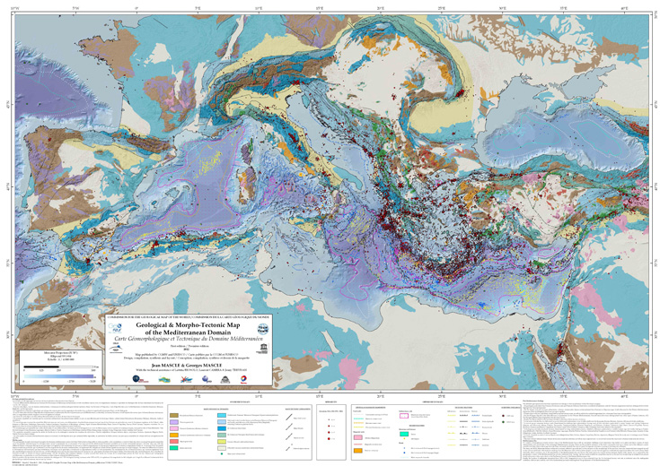
This new map aims to show the main geological/geophysical characteristics of the Mediterranean basin as they have been extracted and synthesized from many publications and unpublished data within a simplified surrounding geological framework. |
Onshore, to reflect that the geodynamics of the Mediterranean area is intimately related to the evolution of the Alpine realm, the different geological units have been assembled according to their implications within the Alpine orogenic evolution.
Offshore major characteristics and specificities of the submerged Mediterranean domain have been selected, such as the extension of the thick continental crust (up to 20 km) and of the different oceanic crust-floored deep basins whose age have also been indicated. Further the various deep, and thick, Messinian basins have been identified and mapped as well as their salt-induced deformations (diapirs or/and various gravity tectonics); mud volcano fields, which constitute one of the specificities of the Mediterranean Sea, are shown. The main active (or recently active) tectonic features, generated by the geodynamic context of the Mediterranean Sea, are also indicated. Finally, the location of earthquake epicentres (magnitude 4 up to 8), from 1974 to 2011, is indicated since the earthquakes underline one of the fundamental processes resulting from the geodynamics of the Mediterranean Sea and the various plates and microplates boundaries (see details in CIESM Workshop Monograph 42 on Marine Geo-hazards).
Built under Arcgis, this map, which results from the superposition of more than 30 distinct layers, is the first one ever published and concerning the whole Mediterranean domain.
This map is available at the CCGM/CGMW headquarters, 77 rue Claude Bernard, 75005 Paris, France www.ccgm.org
|