A new deep site of the CIESM Hydrochanges Program is now operational in the Tyrrhenian Sea thanks to the efforts of an Italian group consisting of DiSAm (Department of Environmental Sciences of the “Parthenope” University of Naples), CNR-ISMAR (Institute for Marine Sciences of the Italian National Research Council, branch of La Spezia), ENEA-UTMAR (Technical Unit for Marine Environment and Sustainable Development of the Italian National Agency for New Technologies, Energy and Sustainable Economic Development, La Spezia) and CoNISMa (Italian Interuniversity Consortium for Marine Sciences).
The instruments were deployed during the cruise VENUS-1 on board of the CNR vessel R/V Urania (17-25 August 2010), which was planned to perform CTD casts, to collect water samples for biogeochemical analysis in the western Mediterranean and to recover and redeploy an oceanographic mooring already located in the Central Tyrrhenian Sea. This mooring, originally deployed in the framework of the VECTOR project, includes current meters, TS sensors and sediment traps. It has worked from April 2007 to January 2009 and from January 2010 up to date.
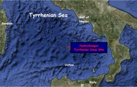
Under the auspices of the Hydrochanges program the mooring (90 km NNE of the Ustica Island and 140 km SW of the Gulf of Naples) was implemented with a SeaBird Electronics Microcat 37 SMP unit (measuring pressure, temperature, conductivity; pumped) and an Aanderaa RCM11 currentmeter in addition to the pre-existing SeaBird Electronics 39, Aanderaa RCM7 and sediment traps.
The maintenance of this site is scheduled each year, and the collaboration among the above institutions will allow to interchange instruments and calibrate them after each recovery.