Morpho-Bathymetry of the Mediterranean Sea

This new CIESM / Ifremer map of the Mediterranean seabed at 1 / 3 000 000 scale (see reduced version and 3D images below) revisits and extensively consolidates previous efforts from the two organizations which provided partial representations - in the Western and Eastern sub-basins - of the morphology of the Mediterranean Sea. While not exhaustive, this new map covers most of the deep Mediterranean basins and illustrates a successful collaboration between 19 Institutes that are listed below.

The remaining gaps mostly concern the Sicily Channel and the southern part of the Ionian Sea. It is a question of time before the shallow Adriatic and Aegean Seas are covered, depending on opportunities and cooperations with our Italian and Greek colleagues.

The suggested reference for this map is: CIESM / Ifremer Medimap Group, Loubrieu B., Mascle J. et al., 2008. Morpho-bathymetry of the Mediterranean Sea, CIESM edition - 30€

Order it now - For map purchasers, Medimap group provides the digital terrain model (DTM) of swath bathymetry of the Mediterranean Sea at a 1 km grid spacing. DTM is provided as an ascii file Latitude/Longitude/Depth. Please contact Benoit Loubrieu, as Ifremer technical representative of the Medimap Group.


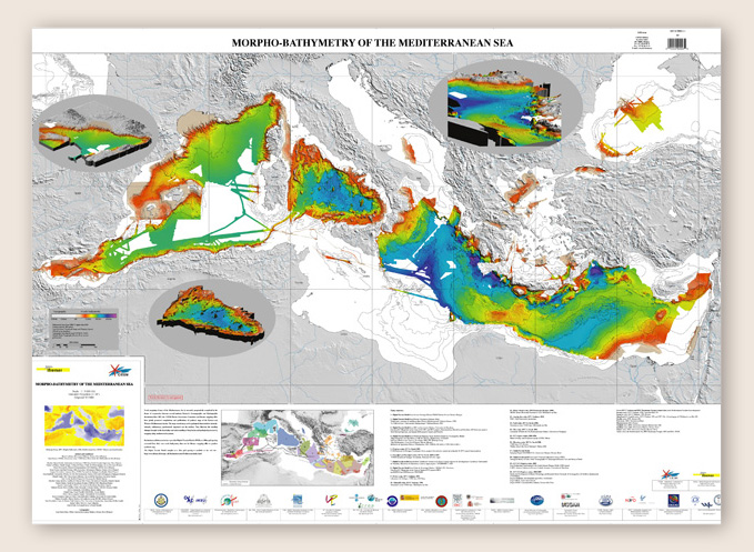
see 3D images: the Northwestern Mediterranean Sea - the Tyrrhenian Sea - the Ionian Sea - the Eastern Mediterranean Sea

List of participating Institutes:

IFREMER: Institut Français de Rercherche pour l’Exploitation de la Mer, Département de Géosciences Marines, Brest;
SHOM: Service Hydrographique et Océanographique de la Marine, Brest;
CNRS/INSU: Centre National de la Recherche Scientifique/Institut National des Sciences de l’Univers, Paris;
OOV: Observatoire Océanologique de Villefranche sur Mer de l’UPMC, UMR Géosciences-Azur;
ENS/Paris: Ecole Normale Supérieure de Paris, Laboratoire de Géologie;
IUEM: Institut Universitaire Européen de la Mer, Université de Bretagne Occidentale, UMR Domaines Océaniques, Brest;
UP: Université de Perpignan, Laboratoire d’Etude des Géo-environnements Marins;
UB/GCR-GM: Universidat de Barcelona, Geociences Marines;
IEO: Instituto Espanol de Oceanographica, Madrid;
IHM: Instituto Hidrografico de la Marina;
CSIC: Instituto Andaluz de Ciencias de la Terra, Unita de Technologia Marina, Granada;
CNR/ISMAR: Istituto di Scienze Marine, Bologna;
HCMR: Hellenic Center for Marine Research, Athens;
NWO: Nederlandse Organisatie voor Wetenschappelijk Onderzoek/Vrije Universiteit Amsterdam;
CRAAG: Centre de Recherche en Astronomie, Astrophysique et Géophysique, Alger;
INBS: Israel National Bathymetric Survey;
OGS/RIMA: Istituto Nazionale di Oceanografia e di Geofisica Sperimentale, Trieste;
DiSGAM: Department of Geological, Environmental and Marine Sciences, Universita di Trieste;
UdC: Universtia della Calabria, Dipartimento di Scienze della Terra.

List of authors and contributors:

Benoît Loubrieu, Géosciences Marines, Ifremer, Brest (France);
Jean Mascle, CIESM and Géosciences Azur, CNRS-Insu, Observatoire de Villefranche sur Mer (France);
Jean Benkhelil, Laboratoire d'Étude des Géo-Environnements Marins, Université de Perpignan, Perpignan (France);
Serge Berné, Géosciences Marines, Ifremer, Brest (France);
Nicolas Chamot-Rooke, Laboratoire de Géologie, CNRS-Insu, Ecole Normale Supérieure, Paris (France);
Jacques Deverchère, IUEM, Université de Bretagne Occidentale, Brest (France);
Laurence Droz, IUEM, Université de Bretagne Occidentale, Brest (France);
Jean-Paul Foucher, Géosciences Marines, Ifremer, Brest (France);
Gilles Lericolais, Géosciences Marines, Ifremer, Brest (France);
Xavier Le Pichon, Collège de France, Chaire de Géodynamique, Aix en Provence (France);
Sébastien Migeon, Géosciences Azur, CNRS-Insu, Observatoire de Villefranche sur Mer (France);
Pierre Mouscardès, Mission Océanographique de l'Atlantique, SHOM, Brest (France);
Claude Rangin, Collège de France, Chaire de Géodynamique, Aix en Provence (France);
Silvia Ceramicola, OGS/RIMA, Trieste (Italia);
Ester Colizza and Angela Cuppari, Università di Trieste, Trieste (Italia);
Daniel Praeg and Nigel Wardell, OGS/RIMA, Trieste (Italia);
Rocco Dominici and Francesco Muto, Università della Calabria, Arcavacata di Rende (Italia);
Michael Marani, Geologia Marina, ISMAR, Bologna (Italia);
Fabio Trincardi, Geologia Marina, ISMAR, Bologna (Italia);
Nevio Zitellini, Geologia Marina, ISMAR, Bologna (Italia);
Miquel Canals, GRC Geociències Marines, Universitat de Barcelona, Barcelona (Spain);
Juan Acosta, Instituto Español de Oceanografía, Madrid (Spain);
Menchu Comas, Instituto Andaluz de Ciencias de la Tierra, Universidad de Granada, Granada (Spain);
Eulàlia Gràcia, Unitat de Tecnologia Marina, CMIMA/CSIC, Barcelona (Spain);
Angelo Camerlenghi, ICREA, Universitat de Barcelona, Barcelona (Spain);
Karim Yelles, CRAAG, Algiers (Algeria);
John Woodside, Centre for Marine Earth Sciences, Vrije Universiteit Amsterdam, Amsterdam (Netherlands);
Matina Alexandri, Marine Geology and Geophysics group, HCMR, Athens (Greece);
John K. Hall, Geological Survey of Israel (Israel).

See also connecting products:
     
      -     Cartography by multibeam echo-sounder of the Nile Deep-Sea Fan    (scale: 1 / 600 000 - 2003 - 25€);
      -     Cartography by multibeam echo-sounder of the Mediterranean Ridge (scale: 1 / 1 500 000 - 2001 - 30€).